 |
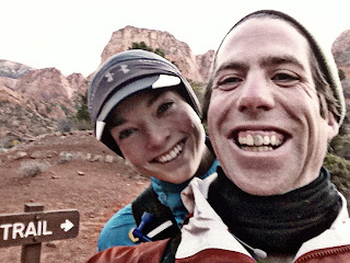
| Candice at the start. Brrrr it was cold. |
Nov. 16, 2011
My Tans-Zion (TZ) crossing was planned totally last minute. As a celebration for my 30th birthday James and I decided to go somewhere warm and do what obsessive runners like us do: a one-day, 42 mile crossing of the Grand Canyon and back, called the R2R2R, or rim-to-rim-to-rim. We set 5 days aside for the trip so that we could explore (ie run) in some of the surrounding areas. But even a 42 mile day wasn't enough for us.
As James was researching where to do our shorter runs during the trip, he discovered the Trans-Zion crossing, a 48 mile (also in the Southwest) unbelievably scenic, and undeniably tough route that is usually done as a week long backpacking trip. James looked up the fastest known times (FKT) for the route and the next thing I knew I’d been convinced to go for a new FKT on the TZ. It really didn’t take any convincing. The previous FKT for a woman was 13 hours and I was pretty sure I could easily break that time. I knew that trying to beat a certain time on the crossing would be damn good motivation and an excellent training run for the season's upcoming 100s. I love racing against the clock, and this would be a fun way to put a little more stress on what would otherwise be a laid back run. It’s easy to go slow on long, fun runs because there’s little motivation (other than to finish the thing) so when you get tired it’s too easy to wimp out. This would not be the case with a FKT on the line.
The challenges of doing a FKT on a trail as opposed to doing a race on a trail is having to do all the research yourself. We would need to know the route, determine where we‘d get water along the trail, and figure out how much food and clothing to bring. There would be no aid stations and we decided to attempt the TZ unsupported: we’d carry everything we needed only using on-route water sources. Although James and I planned to run together, we would not give each the any aid, food, etc, keeping with the plan to run unsupported.
We didn’t know if we would be able to do the crossing until the night before we had planned to run the route. Because the Tans-Zion crossing is a point to point run, you need to leave your car where you will finish and get dropped off at the start. We decided to run from West to East, as it would be easier for us logistically.
After coming into Las Vegas via plane on Tuesday morning we made a few stops. First at a local REI (maps, last minute backpack for me, new Garmin 610 for the trip), then we went to Red Rock Running Company (compression socks and shoes), and lastly we stocked up at Whole Foods (snacks, lunch, and sushi for the run). After our stops, we headed North toward Springdale, our base camp for the next two nights. Springdale is a little town with excellent restaurants, good coffee, and lots of quality, but cheap choices in accommodations. The town has a big focus on outdoor sports like canyoneering, rock climbing, and hiking. It's situated just outside the East Entrance to Zion National Park. Red cliffs tower over the town and cacti grow in the sidewalks.
On the drive to Springdale, James left messages at several outfitters in order to secure a ride the next morning to the West Entrance to the park at Lee Pass trailhead, our planned start point of the La Verkin trail and the Zion-Traverse. At 8pm James get a hold of an outfitter in Springdale, who agreed to drive us to the trailhead at 6am the next morning for just $75. Whew. One of many hurdles down. At this point our Trans-Zion crossing was a definitely going to happen.
|
(section by section)
Lees Pass to Hop Valley
6.8 miles, total time: 1hr 23min
The trail begins winding gently down a hillside with red rocks, red sand, and little river crossings. It took us a few miles to get into a groove. Too much clothing, layers needed to be peeled off. My backpack felt uncomfortable and I had to keep adjusting it. We hit our groove as we climbed the first short hill that lead us into Hop Valley. The first 6.8 miles took 1 hour 23 minutes, a little slower than we’d hoped, but still plenty fast for a FKT. We struggled through sand for much of the first 6.8 miles, slowing us down and straining our legs.
 |
| still bundled up a mile or so into the run |
 |
| James don't eat the map! |
6.6 mile section, total distance: 13.4 miles, time for this section: 1hr 40 min, total time: 3hrs 3 mins
The sand continued on-and-off through the Hop Valley and we crossed a very shallow river several times as we searched for the trail. This valley section was also slower than it needed to be. We had to slow down considerably to find the trail on this section. It kept disappearing, then reappearing on the other side of the river. Then we traveled uphill and out of the valley to the Connector Trail. This section of 6.6 miles took us 1 hour and 40 minutes. There’s definitely room for improvement on this section, especially if you know where the trail is and can keep a good pace on a gradual uphill.
 |
| checking out the view |
 |
| James puts data into the GPS |
8.8 mile section, 22.2 total miles, time for this section: 2hrs 3mins, total time: 5hrs 6 mins
This was a really nice gradual uphill with lots of runnable sections, although the running was strenuous through sand and the continuous, very gradual uphill was tiring. We ran past more than a few incredible rock formations. One memorable formation looked as though a giant had stacked thousands of stone discs on top of each other to form a big round mountain. Another part of the trail led us up and over stone slabs as we followed a few cairns to the dirt trail.
 | |
| Candice pauses on the rocky trail |
 |
| We ran a lot of the gradual uphills |
14.8 mile section, 37 total miles, time for this section: 3hr 14min, total time: 8hr 20 min
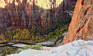
This section was one of the most spectacular. The views stretch out into the canyons and there are several small climbs that boast some excellent views from exposed cliffs. This section has a nice flat-ish trail on the edge of a cliff that zigzags down into a canyon. Right at the top of the descent we encountered a large buck (antlers and all) heading up the trail while we were trying to go down. I had a moment of terror when I realized that he could gore us or throw us off the trail hundreds of feet into the canyon. As I slowly backed up, James started yelling and before I knew it the buck was heading down the trail. We followed him slowly for a quarter mile then he climbed up a steep hillside and was off the shelf trail. Whew.
 |
| you can't see the buck in this picture even though it was right there, so I put the arrow where it was. The buck blends in and the pics are taken with an iPhone, so they're not too high quality |
 |
| magnificent view climbing down the canyon |
 |
| The view down into the Valley (Floor of the Valley Road and the Grotto) |
11.8 mile section, 48.8 total miles, time for this section: 3hr 27 min, total time (finishing time) 11hr 47 min
After the Grotto I knew we'd have a gigantic climb from Weeping Rock up the East Rim trail, about 3-4 miles with 2,000 + feet of elevation gain, and we were feeling pretty tired. I was running the Trans-Zion on 70+ mile training weeks with no taper, so by mile 40 I was feeling the pain!
 |
| Wow |
About 12k from the finish, we ascended the last steep climb and I started to feel like I was bonking. I needed quick calories and overall I felt very tired. James was telling me a story about how he got on the varsity cross country team as a freshman in high school and I was trying to listen to the story but my body was struggling. I stopped a few times, and plodded up that hill. I had put a Cytomax powder in my water before the climb, and it began to work. By the top of the hill I was ready to conquer the last 10k. Then the sun dropped, darkness descended, and the temperatures plummeted in the span of just a few minutes. We struggled to put on layers and get our headlamps out of our packs.
We were too late; my hands began to hurt like hell. They were so cold I couldn't think. I was trying to hold my headlamp in one hand to illuminate the trail, but even with gloves on it was freezing. I kept switching hands with the headlamp so that I could curl my free hand inside the glove and hopefully warm it up. It wasn't working. As a last resort I put my headlamp on my head (not a bad idea, I told you I couldn't think right?) and curled both hands up inside the gloves. Relief came slowly, but it did come within a mile.
The last 3 miles of trail must have been more like 10 miles. It felt like an eternity. At one point the trail forked and the trail sign to the East Entrance pointed toward not one, but two trails. Fuck. I think it's this trail... We followed the most likely trail slightly to the right and I really hoped it was the right one. My fragile psychological state couldn't handle a wrong turn. I wasn't sure how I would handle adding on a few miles when I was so ready to be done, would I curl up and die? Would I start all out bawling? Would I run into the canyons crazy with frustration, never to be seen again? A few miles later, there was still no gate, James seemed to be confident that we'd get there, but I wasn't too sure... where was that East Entrance gate??! Did we go the wrong way?
The dark trail kept playing with my mind, turning me toward what looked like the gate or a park sign, then it would only continue to weave around another hill, the offending hallucination turning into a sage bush or rock. As the GPS read 48.8 miles (0.8 longer than anticipated), we saw the familiar forms of trail signs and a gate, were they real? Sweet, sweet relief washed over me. This time it wasn't a hallucination. We hugged and James congratulated me on a new FKT. All in all, it took me 11 hours and 47 minutes, about an hour slower than I had expected, but I was happy to finish in under 12 hours. Just as we tried to take a picture at the East Gate, James' iPhone died. I wasn't too worried, all I wanted to do was sit down anyway.
Here is the first 7 1/2 hours of the run (as long as my garmin's battery lasted). I have since then purchased the Garmin 310XT, which has a 20 hour battery life.
Photo credit: A big thank you to James Varner for his excellent iPhone picture taking skills. If it weren't for him, I wouldn't have any pics.


No comments:
Post a Comment
Thank you for commenting!